


Voting District 10300, Los Angeles County, California
About
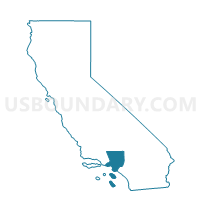
Outline

Summary
| Unique Area Identifier | 534472 |
| Name | Voting District 10300 |
| County | Los Angeles County |
| State | California |
| Area (square miles) | 0.86 |
| Land Area (square miles) | 0.79 |
| Water Area (square miles) | 0.07 |
| % of Land Area | 92.16 |
| % of Water Area | 7.84 |
| Latitude of the Internal Point | 33.93475940 |
| Longtitude of the Internal Point | -118.16955310 |
Maps


Graphs
Select a template below for downloading or customizing gragh for Voting District 10300, Los Angeles County, California


Neighbors
Neighoring Voting District (by Name) Neighboring Voting District on the Map
- Voting District 10312, Los Angeles County, CA
- Voting District 10333, Los Angeles County, CA
- Voting District 10348, Los Angeles County, CA
- Voting District 22550, Los Angeles County, CA
- Voting District 43990, Los Angeles County, CA
- Voting District 44023, Los Angeles County, CA
Top 10 Neighboring County Subdivision (by Population) Neighboring County Subdivision on the Map
- South Gate-East Los Angeles CCD, Los Angeles County, CA (501,237)
- Downey-Norwalk CCD, Los Angeles County, CA (414,144)
- Compton CCD, Los Angeles County, CA (342,576)
Top 10 Neighboring Place (by Population) Neighboring Place on the Map
Top 10 Neighboring Unified School District (by Population) Neighboring Unified School District on the Map
- Los Angeles Unified School District, CA (4,541,134)
- Downey Unified School District, CA (120,994)
- Paramount Unified School District, CA (77,645)
- Lynwood Unified School District, CA (68,397)
Top 10 Neighboring State Legislative District Lower Chamber (by Population) Neighboring State Legislative District Lower Chamber on the Map
Top 10 Neighboring State Legislative District Upper Chamber (by Population) Neighboring State Legislative District Upper Chamber on the Map
Top 10 Neighboring 111th Congressional District (by Population) Neighboring 111th Congressional District on the Map
Top 10 Neighboring Census Tract (by Population) Neighboring Census Tract on the Map
- Census Tract 5362, Los Angeles County, CA (7,289)
- Census Tract 5400, Los Angeles County, CA (6,973)
- Census Tract 5515.01, Los Angeles County, CA (4,869)
- Census Tract 5514.01, Los Angeles County, CA (4,290)
- Census Tract 5361.04, Los Angeles County, CA (4,052)
- Census Tract 5361.02, Los Angeles County, CA (3,164)
- Census Tract 5516, Los Angeles County, CA (31)